Not quite quakes
This post first appeared in my Going Local column in The Bogotá Post
For related post see
Armero on my mind on the deadly volcanic disaster of 1985,
Do you have an altitude problem? on Bogotá’s thin air and
Bogotá’s weather – anyone’s guess…
Did the earth move for you? Sitting in my bedroom in Bogota I feel the floor shift in one long easy sensuous swaying motion that sets the heart racing and the mind groping for an appropriate response. I mean, the ground beneath is supposed to be solid, right. And suddenly it’s not.
For some perverse reason I always enjoy these world-upside-down moments. But in a second it’s over and I run to inform the kids, none of whom feel a thing, and are probably wondering if dad has been at the tequila again. Eventually I drag them to the computer and load the United States Geological Survey ‘Latest Earthquakes’ website that maps real-time seismic data from around the world.
´Look, I am telling you, there was a temblor. Any minute now it will appear on the screen,’ I explain, though so far no red dot has popped up anywhere near Colombia. The USGS site shows the location, depth below the surface, and strength of the seismic event. This tells you if you just felt a small local tremor, or the echo of much larger quake far away.
Even more fascinating is to zoom in and out of the map and watch mosaic of red dots along the planet’s fault-lines – red dots that show significant seismic activity within the previous hour – and realise what while we often image Earth to be like an apple spinning in space, it is really just a large glob of thick cooling custard with some wrinkly skin floating on top. And we’re sitting on the skin.
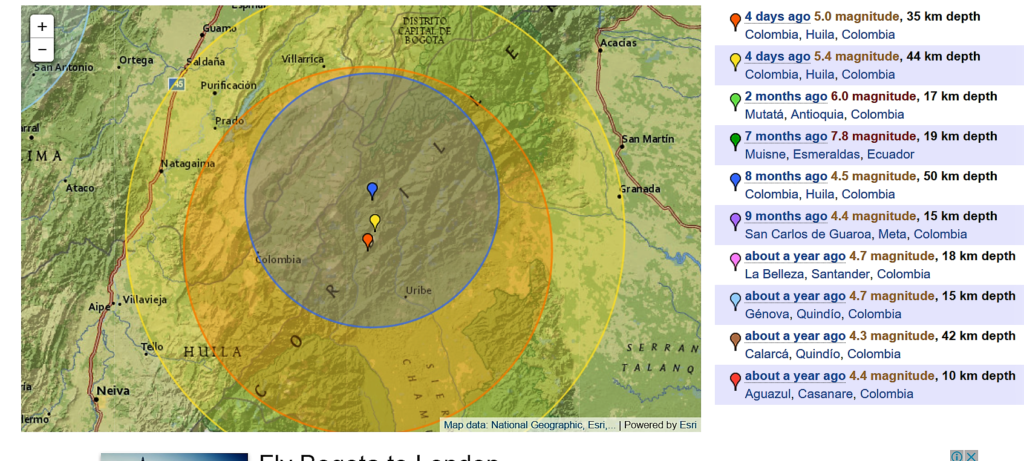
Then, suddenly, a red dot pops up on the map – it’s Colombia! – with the information that at 7.20pm, some 100 kms south of Bogota, was registered a quake of magnitude 5.4, and 44 kms depth, no big deal but enough to keep us on our toes. The timing is perfect, coming just four days after a city-wide emergency simulation, known as the simulacro. And rather bizarrely the epicentre is bang between one village called ‘Colombia’ and another called ‘Uribe’. I’ll leave the conspiracy theorists to mull that one over.
‘See, I did feel something,’ I tell my daughter, pointing at the screen, but she has fled to her room to quickly re-emerge with a bag. She tearfully shows me the content of her ‘earthquake kit’ which includes a torch, spare clothes, water bottle, biscuits and a fluffy toy.
‘You forgot a whistle in case you get stuck under rubble,’ I say, immediately regretting the comment that starts her sobbing. I try and calm the situation by explaining that Bogotá is technically a ´medium risk´ zone, with only a handful of relatively small earthquakes in historic times, and very few deaths. Added to that most buildings are strongly built, our own in particular (as I discover every time I break another drill bit trying to make a hole in the wall).
But the previous week’s simulacro and schoolyard gossip, fed by twaddle on Twitter, has convinced her that Bogota is about to get the Big One. According to ‘reliable sources’ – her 8-year-old friends – the city is going to be levelled by Christmas Eve.
By now some neighbours have congregated in the building foyer to discuss the temblor: that recent heavy rain triggered it (not likely since the quake originates many kilometres below the surface), someone’s cat magically detected the event and vacated the flat a few hours before (probably at the same time it always goes out), that the tremor will ´release the pressure’ in the Andes mountains so no more are coming soon (not likely, since it can take 10,000 small tremors to equal the force of a large quake) and that the tremors are an omen of a larger quake to come, which is possible (though statistically a smaller, same-size event, or nothing at all is just as likely).
In fact the Sunday night temblor does trigger a replica. The aftershock is slightly smaller (magnitude 5) and comes two hours later.
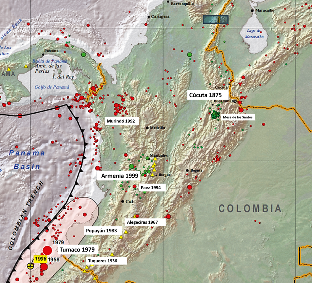
The question for me is: why doesn’t Bogota get more large terremotos? Other parts of Colombia are much more prone, such as the Pacific Coast, swept by a killer tsunami in 1979, and cities in the south-west like Popayan and Armenia (struck down in 1999), and the north-east in Cucuta (which saw Colombia´s largest quake in 1875, with ten thousand dead).
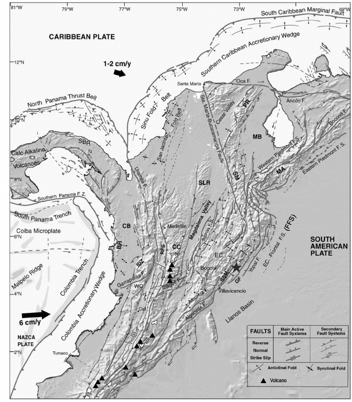
This is strange considering Bogota’s high perch among mountain ridges folded by a convergence of the Nazca, South American and Caribbean plates. Looking at maps it seems that the city has somehow dodged the main fault lines, which normally follow the mountain chains. In the case of the Cordillera Oriental they divide into shorter faults that by-pass the Bogota plateau altogether, only to re-converge in Mesa de los Santos, a hot-spot on the Chicamocha Canyon close to Bucaramanga. Shorter faults only make tremors, say the experts. In seismology, it seems, size matters.
Perhaps that explains the low death toll. Historic records from 1923 to 1997 list 40 people dead and 900 affected by earthquakes in the department of Cundinamarca (including Bogota city). Compare that to 700 people killed and 9,000 affected by landslides in the same area and timespan. Hang on a minute: why aren’t we worrying more about landslides?
Shame the USGS could not spell Colombia….
`People being buried in wet mud is not as sexy as earthquakes, I’m afraid,’ says one friend, who points out that there are not many Hollywood blockbusters focused on landslides. Another mentions that it is usually poor people in marginalised communities on the steep barren hillsides hit by landslides, to which we then say: `well, they should have known better than to live there in the first place’. Sure enough, the most at-risk areas (from both landslides and quakes, according to official ‘vulnerability’ reports) are the sprawling comunas such as Ciudad Bolivar and Cazucathat hug the steep hillsides to the south.
Meanwhile the yearly Bogota-wide simulacro is celebrated by the media andfocuses on large-magnitude earthquakes, complete with parades, presentations and a presidential address. Such exercises usually consist of staff in office buildings filing downstairs, guided by brigadistas, to congregate in the street below for a roll-call.
These simulacros are put to the test in March, 2015, when a real tremor, strong enough to send lamps swinging, rocks Bogota. A friend describes how, on the 9th floor of a government building, some bosses order their staff to keep working. No-one crouches on the floor (the recommended first response, but a bit embarrassing in public) nor makes any effort to leave the building (fire is a risk after a seismic event because of buckled gas pipes).
Some meetings carry on for twenty minutes after the tremor. A colleague nominated as brigadista – actually responsible to clear the floor – keeps typing reports (`just let me send one more email’) before sauntering to the stair-well. Others insist on taking the lift (‘look, it’s still working, so why bother with the stairs?’). It takes 30 minutes for the staff to congregate below.
So perhaps it is just as well that Bogota is only ‘medium risk’. Of course that doesn’t preclude the possibility of a large earthquake hitting the city. But don’t bet the house on it. Anyway, I give my daughter a whistle. Just in case.
Can we predict earthquakes in Colombia?
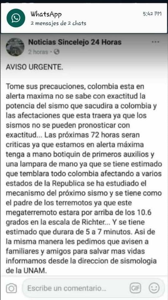
No. Specific earthquakes cannot be predicted. All we can do is map areas where geophysics shows risks, see below, and look at where they happened before. Volcanic eruptions and related tremors can be predicted with some accuracy, but big earthquakes cannot. Unfortunately lots of people in Colombia – including national news feeds that should know better – regularly spread scare stories on social media that ‘the big quake is coming’.
Some friends claim that ‘yesterdays heavy rain could spark a big quake’ (unlikely since quakes originate many kilometres down in the earth, where the rain don’t reach). And a series of small tremors does not mean ‘a bigger quake’ is coming (though many small tremors or ‘replicas’ to often follow a big quake).
Of course it’s not a bad idea to keep people on their toes and ready prepared for an earthquake. So be prepared. But don’t lose too much sleep over the scare stories on social media. They are fake news.
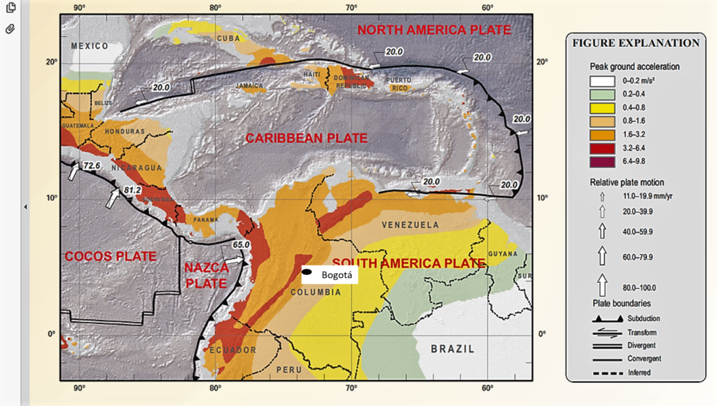
So where are the big earthquakes in Colombia?
OK, Bogotá is ‘medium risk’ so unlikely to suffer a very huge quake. But do check the map below for the high risk areas.
Note that the volcanic mudslide of Armero killed over 20,000 in 1985, see my post on Armero here.